Revitalising the River Ver Project
Update July 2025 Toggle accordion

Update from the Environment Agency
Since our last update, we have completed the tree works and wetland scrape., Parts of the river were in deep shade, Chalk streams need about 70 percent light to 30 percent dappled shade to support the habitats and wildlife they are so well known for. Some trees and large branches have been removed to let sunlight in and increase the abundance of aquatic plants which many insects, fish, water voles and birds rely on.
We have now secured additional funding for this financial year to build upon the work we have already carried out. The works we have planned for this autumn aim to improve the river’s biodiversity and geomorphology (its natural processes, form and shape). We’ll achieve this by introducing woody debris into the channel (using the wood from our tree works), and by creating gravel berms (shelves) at the bottom of the river bed and gravel riffles - shallower areas where faster-flowing water passes over gravels and cobbles on the riverbed, adding oxygen to the water. This will help encourage natural processes to occur by narrowing the river and creating a more varied, meandering channel. The berms will also provide a place for plants to establish, creating new habitats for wildlife.
The exciting discovery of water voles on this stretch of river means we need to take particular care during the works. As you may know, water vole burrows are protected by law. This means that whilst we have surveyed the site, if we come across any additional burrows when carrying out the works, we may have to make slight alterations to our designs to avoid them.
Due to environmental constraints such as trout spawning season, we have a limited window of time to complete the works. We plan to start work on site in September and finish working in the channel by the end of October, the demobilisation of the construction team from the park may extend to November.
We look forward to beginning work on these exciting plans and seeing the positive impact, both on the River Ver and people’s enjoyment of the park and nature. If you have any questions about these works, please contact Angus Richardson at the Environment Agency by emailing angus.richardson@environment-agency.gov.uk
Update February 2025 Toggle accordion
After a short delay, we now have a contract in place for our restoration work to begin on the River Ver from Verulamium Park to Cottonmill Allotments (reaches 2 and 3 of the wider Revitalising the River Ver project). Work is expected to start later this month, with the main works taking approximately 5 weeks to complete. Our aims for this valuable stretch of chalk stream are to:
- increase the amount of natural light reaching the river to support habitats and wildlife by carrying out selective tree works
- improve the park landscape and increase biodiversity by creating valuable wetland habitats, including crossing points to allow visitors to get closer to nature
- improve the paths and bridge to allow all to access the park
Members of our project team have recently updated residents who are either riparian owners or could be affected by the works. As before, these discussions have focussed on the recommendations from a detailed tree survey of all trees in the area, and the need to carry out some tree removal, pollarding and thinning. Chalk streams need about 70 percent light to 30 percent dappled shade to support the habitats and wildlife they are so well known for. The river in reaches 2 and 3 is heavily shaded and the tree works are necessary to increase the amount of natural light reaching the river.
We know how important trees are and the strong feelings often attached to their removal. We will always look to thin, cut back or pollard first and will only consider removing trees if necessary. We always prioritise non-native species, fast growing species, and those in poor condition for removal first.
Other works that will progress alongside the tree works in reaches 2 and 3 include some tree works next to the River Ver in Verulamium Park (reach 1), and the creation of a wetland habitat in the meadow adjacent to Abbey View Athletics Track. The wetlands will improve the park’s biodiversity by providing a habitat for a wide range of wildlife, such as wading birds, and different plant species. It will also help prevent the buildup of stagnant pools of flood water following heavy rain. We expect the wetland to be complete by the end of March/beginning of April.
At the same time, we’ll be completing access improvements in reach 3 (Holwell Hill to Cottonmill Lane) by restoring a riverside footpath and replacing a narrow footbridge only accessible by steps, with a wider, accessible design. We expect to complete this work by the end of March.
We look forward to beginning work on these exciting plans and seeing the positive impact, both on the River Ver and people’s enjoyment of the park and nature. If you have any questions about these works, please contact Angus Richardson at the Environment Agency by emailing angus.richardson@environment-agency.gov.uk
For information about our approved plans for Verulamium Park’s lakes and Bell Meadow (reach 1 of the wider project), you can read our latest press release.
Update October 2024 Toggle accordion
We are making good progress with our plans for Reaches 2 and 3 of the Revitalising the River Ver Project. In our last update, we shared our designs for the tree and in-channel river restoration works to be completed in Reaches 2 and 3. We have secured the funding for these works and are looking to complete the tree works later this Autumn. Reach 1 tree works will also be carried out at this time and will focus on deshading of the river and canalised section through the Park. These works form part of a wider project, where the Environment Agency and St Albans District Council are working together to revitalise the River Ver.
As you may know, the River Ver is a globally rare chalk stream. As a rule of thumb, chalk streams need about 70% light to 30% dappled shade to support the habitats and wildlife that they are so well known for. The River Ver in Reaches 1, 2 and 3 is heavily shaded, which is why the tree works we’re completing are needed. These works will increase the amount of natural light reaching the river. Without this, the river can’t support the plants which the river ecology relies on.
Trees are an important part of our ecosystems, and we appreciate that tree work and removal can be an emotive subject for all of us. That’s why we’ve completed a detailed tree survey and have shared and discussed our plans with local residents, stakeholders, and riparian owners. We have carefully designed our plans, only removing trees where necessary. We have prioritised non-native species, fast growing species, and those in poor condition for removal first.
We are planning to complete the accompanying in-channel works in Spring of 2025 to ensure works do not disturb fish spawning season.
This winter will also see the first stage of access improvement works in Reach 3 (Holwell Hill to Cottonmill Lane) these works will include path restoration and replacing a narrow footbridge only accessible by steps with a new accessible bridge.
If you have any questions or would like to discuss our plans further, please contact Liam Dennis, Project Manager
Update June 2024 Toggle accordion
This is a hugely complicated project with many conflicting constraints. As a result it is unfortunately taking longer than we would hope. Funding remains a significant challenge. The Environment Agency estimates delivery cost for the whole project have significantly increased due to high inflation.
Reach 1. Verulamium Park, Bell Meadow and Lakes
Reach 1 has, to date, taken much longer than anticipated. This is largely due to the complex nature of the issues and the many constraints to navigate. The alignment of the new river channel and how it passes through the Scheduled Ancient Monument at Bell Meadow being the main problem. The flood.
Ground investigation and archaeological assessment were in progress in Bell Meadow (Reach 1), but the ongoing flooding has brought that to a standstill and can’t progress further until the ground dries out. The results of these assessments will enable Historic England and the Planning Authority to make their decision regarding our Scheduled Ancient Monument (SAM) application which is required for planning consent to be granted.
The Council Parks and Green Spaces team will shortly start engaging with riparian landowners regarding tree work along the riverbank in Reach 1 (Bell Meadow and between the Lakes and River.
Reach 2 and 3. Verulamium Park, Causeway up to Cottonmill Allotments
The Environment Agency are currently focused on finalising the detailed designs for Reach 2 and 3. Once they are completed, public engagement and a planning application (if needed) will follow.
The Environment Agency have funding in place to deliver in-channel river restoration and tree works this financial year in Reaches 2 and 3 and will shortly be starting the process of engaging with riparian landowners.
Flooding
Rainfall this year has been exceptionally high. In February 2024 Hertfordshire and North London received 111 mm of rainfall which is approximately 272% of the long-term average which is the highest recorded since February 1951.
During April 2024 rainfall across Hertfordshire and North London remained high at 69mm recorded, 139% of the long-term average rainfall for the month.
River flow has started to decline, but flows are still exceptionally high for the time of year.
Groundwater levels in the area also remain exceptionally high recording their highest April level since 2001.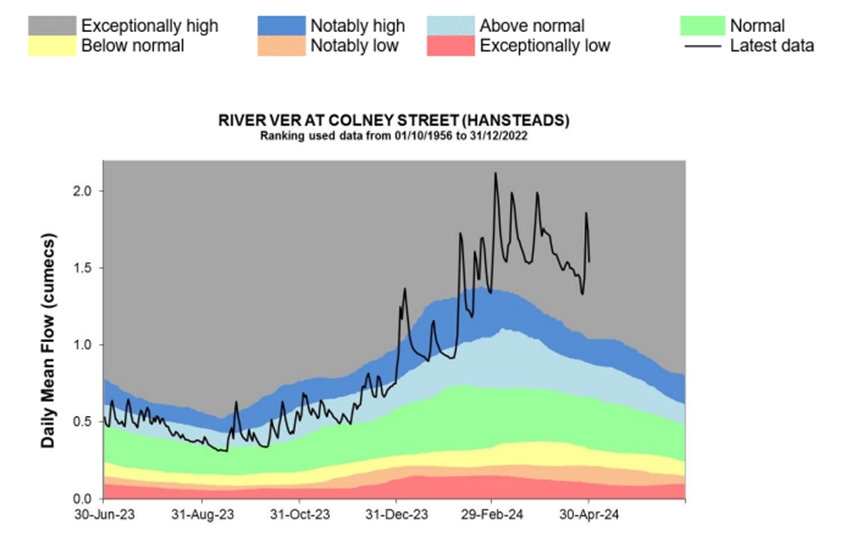 Exceptionally high groundwater levels mean the land can’t soak up the rainfall which eventually ends up flooding off the surrounding land into the river.
Road run off also introduces pollution from the roads in the Batchwood area which floods into the River near Bluehouse Hill.
All these factors have resulted in the ongoing flooding we have seen in the Park this winter season.
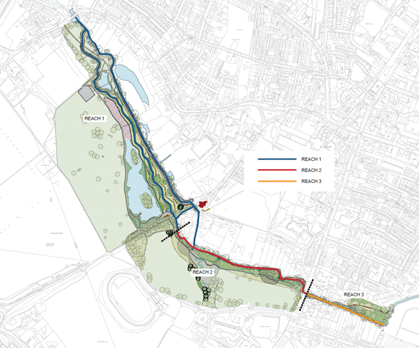
All the low-lying areas of the park along the valley bottom are flood plain and as such have a “Flood zone 3” classification set by the EA as indicated on the plan below.
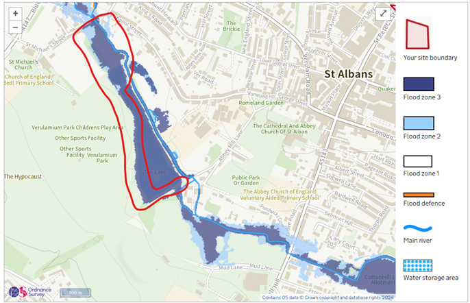
There is no doubt that the flooding is inconvenient, but the flood plains play an important park in flood risk management. They are like a huge sponge and help reduce the risk of flooding elsewhere downstream such as people’s homes and businesses.
It is not an objective of the Revitalising the River Ver project to prevent the park flooding. As mentioned above, many of the low-lying areas of the park are classified as Flood Zone 3. The project is aiming to make the river and lakes more sustainable and resilient for wildlife. The project also aims to make the Park more resilient to extreme conditions by having infrastructure that can still be utilised during flood events.
Update February 2024 Toggle accordion
This is a hugely complicated project with many conflicting constraints. As a result it is unfortunately taking longer than we would hope.
Reach 1. Verulamium Park, Bell Meadow and Lakes
Reach 1 - A preferred design has been identified; however, the EA (Environment Agency) and the Council is awaiting final archaeology results which have been delayed due to flooding.
The results will enable a Scheduled Ancient Monument consent application to be submitted to Historic England for consideration.
Funding remains a significant challenge; the Environment Agency estimates that the delivery cost for the whole project has increased due to inflation.
Reach 2 and 3. Verulamium Park, Causeway up to Cottonmill Allotments
Reach 2 and 3. The EA is in the final stages of developing the design. They are also currently engaging with riparian owners on the work required in the river channel and any tree works.

The River Ver
The River Ver in St Albans flows through Verulamium Park and the heart of the city. It is one of around only 200 chalk rivers in the entire world.
Chalk rivers are fed from the chalk aquifer (the underground layer of rock saturated with groundwater). They are naturally crystal clear and support a huge diversity of habitats and wildlife. Their rarity and importance have led them to be described as ‘England’s Rainforest’.
Unfortunately, like many chalk rivers, the River Ver has fallen into a bad state. In St Albans, the river channel has been heavily modified over the years. The concrete banks mean it can’t support the habitats it should. In places, the river channel has been moved to support industry such as mills. This has led to an artificially over-wide, over-straight channel and sluggish flows. These alterations contribute to the gravel bed being smothered with a thick layer of silt.
The river is also unable to support the iconic chalk stream plants we would like to see. One reason is that the channel is also overshadowed by trees which prevents light reaching the river and allowing chalk river plants to thrive.
Verulamium Park Lakes
Built in the 1930s, the iconic ornamental lakes of Verulamium Park are also in a bad way. They are far too large for the flow they receive and are clogged with silt. The large numbers of non-native Canada geese add to this issue as their droppings contribute to the poor water quality. These issues are especially bad in summer months when so many people come to enjoy coming to the park.
Mission statement & project objectives Toggle accordion
Mission Statement
To deliver a publically supported, award-winning project and legacy on time and within budget through collaboration and efficient communication.
Our objectives
We will revitalise the water environment in Verulamium Park and build a legacy that St Albans residents and visitors will value, enjoy and benefit from. We will bring back a more natural chalk river, more resilient to climate change and better able to support iconic chalk stream biodiversity. We will restore the natural heritage of St Albans; creating more sustainable lakes and an improved park.
| Outcomes and product | Collaboration and people | Aspirations |
|---|---|---|
|
|
|
Revitalising Chalk Rivers Toggle accordion
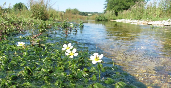 This project is part of Revitalising Chalk Rivers. Together, the Environment Agency, Affinity Water and other local partners are working to protect and restore our local chalk rivers. Numerous river restoration projects have been completed or planned. Alongside these projects we are reducing abstraction (pumping or removing water from the groundwater or a river) to improve flows in the river.
The River Ver is in the River Colne Catchment Area. You can find out more about how our partners are working together to protect and improve the water environment for everyone by visiting the Colne Catchment Partnership website here.
Save water Toggle accordion
Using water efficiently will help ensure we all have enough water for our homes, to produce food, for products and services, and to protect our valuable natural environment. Abstraction of water can have a direct impact on chalk streams, and a large portion of water abstracted is used to meet the demand of the local population. In fact, Hertfordshire has some of the highest rates of water use per person in the country. Therefore, reducing your water use could directly benefit the chalk streams.
Many people are not aware that actions like tipping waste liquids down roadside drains, flushing wet wipes or washing up greasy pans in the sink directly harms wildlife and affects water quality by causing pollution in local rivers, lakes and the sea.
Here are ten simple tips you can follow to help reduce your personal water usage:
Ten Top Tips for Saving Water
- Remember to turn off the tap while brushing your teeth – a running tap wastes approximately 6 litres of water per minute
- Take shallower baths. Running your bath just an inch shorter than usual can save on average 5 litres of water
- When you’re finished in the bath, reuse your bathwater to water your houseplants or garden
- Switch to a low-flow shower head. This will reduce your water consumption but still give you the feel of a normal shower
- Use a shower timer to help reduce shower time. If everyone used a shower timer we would save enough water to supply 1 million homes every day
- When washing up, use a plug or washing up bowl to limit the amount of water used rather than continuously running the tap.
- Make sure the dishwasher is only run when it has a full load
- Fill the kettle with only what is needed, this saves electricity too!
- Use a watering can instead of a hosepipe when watering your garden
- Install a water butt in your garden. You can use the collected water to water your garden or wash the car
Cllr Working Group Toggle accordion
Cllr Working Group is a non-executive body. Its purpose is to provide guidance, assistance and support to the Chair of the Public Realm Committee and the project team on the subject of Revitalising the River Ver and the Lakes in Verulamium Park.
The Working Group meets as and when significant new information is available and when key decisions need to be discussed.
Revitalising the River Ver Working Group

